
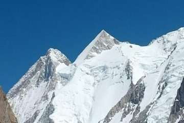
The Expedition of K2 is considered to be one of the top mountaineering adventures in the world. British surveyor Thomas George Montgomerie named K2 in 1852 after measuring its height at 8,611 meters. While surveying from Mount Haramukh. Locally, people call it Chogho Ri, meaning “King of Mountains” in the Balti language. Later, geographers renamed it Mount Godwin-Austen in honor of Henry Haversham Godwin-Austen. Due to its massive size and extreme difficulty, climbers often call K2 the “Savage”, and Reinhold Messner famously described it as the most impressive yet most challenging peak. K2 dominates the Karakoram Range as its highest summit and stands as the world’s second-highest mountain, just 237 meters shorter than Mount Everest.
MAIN ATTRACTIONS
K2’s famous nickname is “Savage Mountain” because of the extreme risks it poses to climbers—frequent avalanches and harsh weather. The Italian Duke of Abruzzi led the K2 expedition in 1909 but gave up at about 6,250 meters. After many other failures, another Italian team eventually succeeded, following a southeastern ridge on the southwestern face in 1954.
Name of Peak K-2 (Chogho Ri)
Height 8611-M (28,251 ft.)
Ranked 2nd: (1st in Pakistan)
Location Karakoram-Baltoro Skardu
Best Period June 10 – August 10
Base Camp height 5150 m
Latitude 35°- 53 N
Durations 60 Days
First Ascent July 31, 1954(964 in total till August 2025)
Day 01: Arrival in Islamabad
Arrival at the airport, followed by a transfer to the hotel. Overnight stay in the hotel in Islamabad.
Day 02: Islamabad To Skardu (By Air)
Early morning flight to Skardu (subject to weather conditions); if unable to fly, we will depart by road with an overnight stay in Chilas.
Day 03: Chilas To Skardu
In case the flight has operated, we will go for a sightseeing tour of Skardu, and in case of no flight, the day will be used for overland travel from Chilas to Skardu (total drive is 22 – 24 hrs from Islamabad to Skardu). Overnight stay in the hotel in Skardu.
Day 04: Rest Day At Skardu
Sightseeing in Skardu, final packing for the Expedition.
Day 05: Skardu To Askole
After Breakfast, we will embark on jeeps for a full-day ride on a winding jeep trail to Askole – The last inhabited place on our way to the Great Glaciers. (Tent) Have your dinner and go for a good sleep. If you enjoyed the ride and are not tired, then you can explore the village of Askoli and its streets.
Day 06: Askole To Jhula
Details to Know
- Distance: around 18-20 km
- Elevation: about 160+ meters
- Time: 5-8 hours
- Difficulty: Easy, but needs commitment
Trek along the Braldu River. The terrain is quite easy, and we will have good tracks here until Pajju. We will have our lunch at Korofoung after a few hours of trek. Mostly, the tour agency provides you with a packed lunch, but a few would make a soft lunch at Korofoung. This place is near the junction of the Panma and Braldo River, and is at the snout of the Biafo Glacier.
Lunch consists of
- Local bread (paratha/chappati)
- Boiled eggs and potatoes
- Soup/ hot tea/ coffee
- Boil water to refill your empty bottles
- Dry fruits and biscuits
- Cans of Tuna and Sardines
We will continue our trek for another 2-3 hours to reach the Jhola campsite. It serves as a crucial stopping point on the K2 Base Camp trek and other routes like the Panma Glacier Sim Pass trek. After crossing the wooden bridge, there is a 90-minute trek to the original Jhula camp with the river on the left in the valley, but more groups prefer to stay at the bank of the river just after crossing the bridge to save energy and time for tomorrow.
The condition of this camp here doesn’t have the facilities like the original Jhola camp, such as water availability, washrooms, and shade on sunny days. But the staff will provide you with boiled water and place your toilet tent near the river.
Day 07: Jhula To Paiju
| Quick Stats | Details |
| Duration | Around 7-8 hours |
| Altitude Gain | 318m ( 3100m to 3418m) |
| Difficulty | Challenging and tougher on a sunny day |
| Highlight | View of Pajju Peak(6610m) and the Snouts of Baltoro Glacier |
Phase 1: Morning March along the Braldu (3 hours)
-
-
The Power Breakfast: Fuel up with a substantial, locally-sourced breakfast. Hydration is key!
-
River’s Edge: The initial hours are spent following the mighty Braldu River upstream. The path is generally flat or gently ascending, traversing through the rugged valley floor.
-
Acclimatization Focus: Our seasoned guides maintain a sustainable trekking pace to ensure proper acclimatization. Today’s steady climb is essential preparation for the higher altitudes ahead.
-
Phase 2: The Ascent and the Big Reveal (3 hours)
-
Rocky Transition: The trail begins to climb more steadily as we move away from the immediate riverbank. Expect rocky paths and scree sections. This is your first true mountain workout.
-
Lunch with a View: We pause for lunch at t, likely halfway, offering expansive views of the lower Karakoram mountains.
- Mungroung will be our lunch point with a small hut/shop to have some Coke and lunch in a quite open area.
- Water Obstacles: Depending on glacial melt, you may encounter one or two small, seasonal meltwater streams. Our team ensures safe crossings, but this is the moment for your trusty waterproof boots or river-crossing shoes!
-
As you approach Paiju, the magic begins! The first distant, yet unmistakable, views of the world-famous Baltoro Glacier, Bakhor Das Peak, and Pajju Peak start to emerge on the horizon. This sight is your Ultimate Trekking Reward.
Phase 3: Arrival at the Last Green Oasis (2 hours)
-
The Oasis: Paiju (meaning ‘salt’ in Balti) is a welcoming, relatively flat campsite, often featuring the last visible trees and greenery before the Baltoro Glacier. It serves as a vital rest and purification point during this journey.
-
Afternoon Activity: Upon arrival, settle into your comfortable tent camp. Our team will lead a short, optional Acclimatization Walk to a viewpoint, enhancing your body’s ability to adjust to the altitude (approx 3,418m).
-
Campfire & Stories: Enjoy a delicious hot dinner under the massive stars of the Karakoram. Share stories and prepare mentally for an epic day hike tomorrow, the entrance onto the Ice Highway!
Day 08: Rest Day At Paiju
Phase 1: Morning – Hydrate and Rejuvenate (9:00 AM)
-
Sleep In & Hydrate: Enjoy a slightly later start. The focus is on quality sleep and maximum hydration. Our team provides an array of hot drinks (tea, coffee, herbal infusions) to kickstart your fluid intake.
-
The Optional Acclimatization Hike: For those feeling energetic and to aid in the acclimatization process, our expert guide will lead a short, gentle ascent up the nearby ridge behind the camp towards Pajju Peak.
-
The Reward: This short effort delivers phenomenal, unobstructed morning views of the Trango Towers, Cathedral Peak, and the dramatic Paiju Peak—perfect light for photography!
-
Phase 2: Midday – Mind and Body Reset (12:00 PM)
-
The High-Altitude Spa: Take advantage of the Last Bucket Shower before the glacier! The camp often has simple, private shower tents. Even a quick wash of face and hair is a massive mood booster.
-
Laundry Moment: It’s your final chance to do any quick, hand-wash laundry that has a high chance of drying in the sun before the cold, damp conditions of the glacial camps.
-
Cultural Exchange: This day is traditionally the Porters’ Rest Day. Observe (and perhaps join!) the legendary Porters’ Celebration. Our local Balti crew slaughters goats (used for meat on the glacier stages) and local bakes roti (bread) for the journey ahead, often accompanied by traditional singing and dancing. This is an authentic Cultural Immersion Experience!
Phase 3: Afternoon & Evening – Gear Check (3:00 PM onwards)
Gear Prep Session: Our guide will conduct an optional, essential workshop on Glacier Safety and Moraine Walking. Use the afternoon to organize your pack, check your gear, and prep your water bottles for the start of the icy trekking tomorrow.
Mountain Zen: Relax, read a book, journal, or simply sit outside your tent and soak in the magnitude of the granite walls surrounding you.
“The mountains whisper here. Listen closely.”
Briefing: A final evening briefing confirms the demanding plan for the next day’s entry onto the Baltoro Glacier, ensuring every trekker is confident and ready.
Day 09: Paiju Camp to Khuburse Camp
Quick Trek Facts
-
Trekking Distance: 14km to 15km (8.5 to 9.3 miles).
-
Altitude Gain: 370 m (from Paiju 3,420 m to Khoburtse 3,795 m).
-
Duration: 6 to 8 hours of strenuous trekking.
-
Difficulty: Strenuous. The footing is highly unstable and uneven. Continued challenging footing on the moraine, but the short duration limits exhaustion.
Phase 1: Morning Moraine Walk (1.5 – 2 Hours)
-
Steady Pace: The morning starts with a continuation of the moraine traverse. Since this is an acclimatization day, a slow, steady rhythm is key.
-
Paiju Side Trail: The day begins with a walk on the final, small river-stone paths and sand of the Braldu River valley floor, leaving the green trees and water sources of Paiju behind.
-
The Glacial Snout: After about an hour, the trail leads directly to the massive, black-ice snout of the Paiju Glacier, where it merges with the Braldu River.
-
Terrain: Expect the same challenging, uneven rocky surface, demanding constant attention to foot placement.
-
Glacier Views: The sheer scale of the Baltoro Glacier is undeniable here. The views are vast, with towering peaks forming the south wall of the valley like the majestic Trango Tower and Pajju Peak on your left.
Phase 2: Lunch Stop at Liligo (1 Hour)
-
The Mid-Way Mark: Liligo is reached after approximately 90 minutes to 2 hours of trekking. It is a small, relatively flat area nestled on the lateral moraine.
-
Function: Liligo serves as an essential staging and rest area, often used by porters and sometimes for emergency camping.
-
The Lunch Setup: Your support crew will have strategically moved ahead to set up a clean, sheltered spot among the boulders. Enjoy a hot drink and a fresh, packed lunch to replenish energy for the second, shorter half of the day.
-
Vitals Check: This is the perfect time for a mandatory water and snack break and a quick check-in with your guides regarding altitude symptoms.
Phase 3: The Final Climb to Khuburse (1 – 1.5 Hours)
-
Leaving Liligo: Re-energized, the final leg is short but includes the steepest section of the day.
-
The Terrace Ascent: You will ascend sharply from the edge of the glacier up onto a well-defined, natural shelf or terrace carved into the valley wall.
-
Dramatic Arrival: Arriving at Urdukas is stunning. You are now perched high above the main body of the Baltoro Glacier, providing a vantage point with incredible depth and perspective.
Phase 4: Khuburse Camp & Acclimatization
-
Spectacular Campsite: Khuburse is one of the most beloved campsites, offering some protection and the best views looking back down the valley and across at the powerful granite formations of the Trango Cathedrals.
-
Afternoon Rest: The short trekking duration leaves the entire afternoon free for rest, journaling, taking photos, and further passive acclimatization—crucial for adapting to the new altitude.
-
Historical Note: Look for the natural rock caves on the terrace, historically used by local porters and early explorers for shelter.
Day 10: Urdukas To Goro II
This day is specifically designed for safe altitude gain and maximum enjoyment of the views. We cover a shorter distance, continuing the traverse of the Baltoro Moraine before making a final, dramatic climb to the historic Urdukas terrace.
Quick Trek Facts
-
Trekking Distance: approx. 6-8 km (3.7 to 5 miles).
-
Altitude Gain: 105 m(from Khoburtse 3,795 m to Urdukas 3,900.
-
Duration: 3 to 4 hours.
-
Difficulty: Moderate to Challenging. The duration is short, but the footing on the moraine is still demanding.
Phase 1: Morning Traverse (1.5 – 2 Hours)
-
The Start: Begin the morning from the Khoburtse campsite, which is situated directly on the Baltoro Moraine. The temperature will be cold, demanding warm layers.
-
Terrain: The initial hours involve walking over the same rough, uneven glacial moraine—a surface of rock, rubble, and dirt concealing the ice below. Maintain a slow, deliberate pace to manage the unstable footing.
-
Focus on Views: Since the day is shorter, take time to appreciate the immense scale of the glacier. Look back down the valley for a final perspective of the Trango Group as they recede into the distance.
-
Glacier Dynamics: Listen for the sounds of running water beneath the debris and watch for meltwater streams that need to be carefully stepped over.
Phase 2: Lunch Stop
As today is a shorter trek, a full lunch will be prepared at Urdukas. You gain more elevation compared to your earlier trek.
Phase 3: Arrival and Camp Life at Urdukas
-
Campsite: Urdukas is considered one of the most beautiful and protected campsites. It is set on a series of tiered, semi-green terraces perched high above the glacier.
-
Historical Features: Explore the site and view the famous natural rock caves used by local porters and climbers for centuries.
-
Key Views: The camp offers commanding views of Biale Peak/ Biale Kangri 6729m and the incredible, massive rock formations known as the Trango Cathedrals to the south.
-
Acclimatization: Due to the short trek, the entire afternoon is dedicated to rest and passive acclimatization, which is critical at this altitude before the push towards Ghoro 2.
Day 11: Rdukas to Ghoro 2
This is a longer, high-altitude day, but the challenge is offset by the spectacular rewards. The trail leaves the lateral moraine and moves directly onto the central glacier, delivering the first full, jaw-dropping views of some of the world’s most impressive peaks.
Quick Trek Facts
-
Trekking Distance: 12km (7.5 miles).
-
Altitude Gain: 380m (from Urdukas 3,900m to Goro 2, approx 4,280m.
-
Duration: 5 to 7 hours.
-
Difficulty: Strenuous. The distance and altitude are significant, requiring high stamina and endurance.
Phase 1: Leaving the Terrace (1 – 1.5 Hours)
-
Departure: Begin with an early start from the comfortable Urdukas terrace. The initial part involves a short descent back onto the main body of the Baltoro Glacier.
- Rdukus will be the last area to be tented on rough soil or a dry place.
-
Stable Ground Ends: You leave the relative stability of the Urdukas rocky path and transition back to the glacial moraine.
- Around an hour later, you leave Rdukus, you will see the first mighty peak, the Gasherbrum IV (7,925 m), standing tall right at the end of the Baltoro glacier. This sight will remain with you till you reach Concordia.
-
Terrain Shift: Unlike previous days, the path becomes less about navigating massive, broken boulders and more about walking on the central glacier, where the moraine is often covered by smaller, smoother rocks and sometimes patches of exposed ice. Footing, while still uneven, can be slightly easier than the Khoburtse-Urdukas stage.
Phase 2: The Glacier Highway to Goro 1 (2 – 2.5 Hours)
-
Central Traverse: The majority of the morning is spent walking directly up the center of the vast Baltoro Glacier, following the natural flow lines of the ice.
-
The Big Reveal: Look ahead to the massive, conical form of Masherbrum (K1, 7,821m), which dominates the south side of the valley, providing your first glimpse of a true 8,000-meter-class giant.
-
Ice Formations: You will walk past surreal formations of glacial ice that have melted, known as seracs and penitentes.
Phase 3: Lunch Stop at Goro 1 (1 Hour)
-
The Midway Point: Goro 1 is reached around midday. This site is typically a very basic, exposed rock shelter or a cleared area on the open glacier, often marked by simple stone walls built by porters.
-
Vantage Point: This spot offers one of the most magnificent mid-trek views, with the peaks surrounding you in all directions.
-
The Lunch Setup: Your crew will quickly set up a sheltered spot for a well-deserved hot lunch and drinks, allowing a full hour of rest before continuing the ascent.
Phase 4: Goro 1 to Goro 2 (1.5 – 2 Hours)
-
Renewed Push: The afternoon segment is shorter but takes you to a higher altitude, making it critical to maintain hydration and a slow pace.
-
Peak Watch: The views continue to improve. The slender, striking spire of the Muztagh Tower (7,284m) often comes into view, the unique, massive shape of Mitre Peak (6,010m) becomes clearer, and the Mashabrum Peak(K1) on the southern side of the campsite.
-
Campsite: Goro 2 is a very exposed, cold, and windy campsite located directly on the glacier. It is marked by flat, clear areas surrounded by low stone windbreaks.
-
Altitude Note: At an elevation of approximately 4,280m, the temperature will drop sharply as the sun sets. This is a cold camp, and warm clothing is essential.
-
Evening Views: If the clouds are clear, you are rewarded with an incredible panorama including Masherbrum, Muztagh Tower, and the peaks guarding Concordia. It is here that you truly feel the remoteness of the High Karakoram.
Day 12: Ghoro 2 to Concordia
| Metric | Details |
| Stage | Goro (Goro II) to Concordia |
| Duration | 5-7 hours of trekking |
| Distance | Approximately 14 km (7.3 – 7.6 miles) |
| Start Altitude | Goro 2: 4250m |
| End Altitude | Concordia: 4600m |
| Elevation Gain | approx. 600m up |
| Terrain | Mostly the smooth, central moraine of the Baltoro Glacier. Easier footing than the previous day. |
This day is an absolute highlight of the Karakoram journey, often described as trekking into the “Throne Room of the Mountain Gods.”
-
Start: You wake up at the cold, wide campsite of Goro II, with sensational morning views of Masherbrum (K1) and the iconic spire of Gasherbrum IV.
-
Mid-Trek: You follow the flow of the mighty Baltoro Glacier, walking past the junction where other peaks like the Marble Peak and Crystal Peak come into view.
-
The Reveal: The best part of the day is the final approach to Concordia. K2 is completely hidden until the very last turn as you reach the confluence of the Godwin Austen and Baltoro Glaciers.
-
Arrival: Upon arriving at Concordia, you are standing in a massive, glacial amphitheater, surrounded by four of the world’s 14 8,000-meter peaks (K2, Broad Peak, Gasherbrum I, and Gasherbrum II), along with the majestic Golden Throne (Baltoro Kangri) and Mitre Peak.
The campsite at Concordia is usually set up right on the glacier moraine, giving you an unparalleled, 360-degree view of the Karakoram giants.
Day 13: Concordia to K2 basecamp
| Metric | Details |
| Stage | Concordia to K2 Base Camp (K2BC) |
| Duration | 9 – 11 hours of trekking |
| Distance | Approximately 25 – 28 km (15.5 – 17.5 miles) |
| Start Altitude | Concordia: 4,500meters |
| End Altitude | K2 Base Camp: 5,150 meters |
| Elevation Gain | 450 meters up |
| Terrain | The Godwin-Austen Glacier. Mixed ice and moraine. Requires careful footing. |
-
Early Start: To complete this journey in a day, you will start very early, often before dawn, to take advantage of the frozen, firmer glacier.
-
The Ascent: The route follows the Godwin-Austen Glacier, which flows down from the massive peaks of K2 and Broad Peak. The walking can be challenging, involving navigating the ice-covered glacier moraine.
-
Broad Peak Base Camp (BPBC): About halfway, you will pass Broad Peak Base Camp (approx. 4,800m). Many expeditions use this as a stopping point.
-
The Final Push: From BPBC, it’s a couple more hours of difficult trekking to reach the K2 Base Camp area, right at the base of the massive mountain.
-
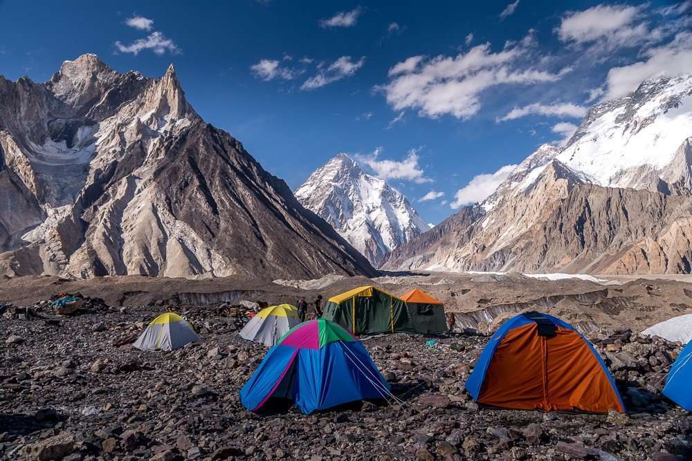
K2 Base Camp (K2BC): This is a vast, desolate area. You may see the colorful tents of current climbing expeditions (in season). The main objective is to stand at the foot of K2 and appreciate its sheer, intimidating scale.
Day -14:
K2 (8,611m / 28,251ft) Expedition Details
1. Key Routes and Technical Difficulty
The climb is almost exclusively done from the Pakistani side. No route on K2 is suitable for beginners.
| Route Name | Description | Key Difficulties / Hazards |
| Abruzzi Spur (South-East Ridge) | The standard and most common route (used by 75% of climbers) was first iestablished n 1954. | House’s Chimney (a 40m technical rock/ice wall near Camp 2), The Black Pyramid (complex mixed climbing section), and the Bottleneck. |
| Cesen Route (South-Southeast Spur) | A more direct, steeper, and technically demanding route than the Abruzzi, often considered less exposed to rockfall in the lower sections. | Extremely steep ice and snow slopes, requiring advanced technical climbing. Connects with the Abruzzi Spur near the Shoulder. |
| The Bottleneck (Crux) | A narrow, steep couloir (ice chute) located at approx 8,200m, just below a massive, unstable hanging glacier (serac). | Objective hazards (risks not controlled by the climber), such as ice chunks and avalanches, can fall from the serac. It is the most dangerous section of the entire mountain. |
2. Standard Expedition Timeline
A K2 expedition is a long commitment, typically lasting 50 to 60 days from arrival in Islamabad to departure.
| Phase | Duration (Approx.) | Key Activities |
| Trek In | 10–14 Days | Travel from Islamabad/Skardu, 4×4 drive to Askole, and trek to K2 Base Camp (K2BC 5,150m). |
| Climbing & Acclimatization | 30–45 Days | The core period for establishing and stocking high camps (C1, C2, C3, C4) and conducting acclimatization rotations. Climbers ascend and descend repeatedly to prepare their bodies for the “Death Zone.” |
| Summit Push | 5–8 Days | A single, coordinated ascent from K2BC to C1, C2, C3, C4, the summit, and back down to K2BC, usually initiated during a predicted “weather window.” |
| Trek Out | 4–7 Days | Rapid descent from K2BC back to Skardu via the same route/Ghandoghoro pass and drive/fly to Islamabad. |
3. Season and Weather
-
Best Time to Climb: July and August (Summer). K2’s specific location means it largely avoids the heavy monsoon rains that affect the Himalayas (like Everest) at this time, offering a more stable, though still harsh, weather window.
-
Altitude Temperatures: Even in summer, temperatures hover around 0 to 5 degrees during the day, dropping well below freezing at night. At the summit, temperatures are consistently below -30, and the wind chill is extreme.
-
Hazards: Unpredictable, sudden storms and very high winds are major factors, in addition to the significant risk of rockfall and avalanches (especially in the Black Pyramid and Bottleneck sections).
Day 43: Cleaning the Basecamp
After our expedition ends, all the crew members at the basecamp will clean up the basecamp mandatorily.
Day 44: Leave Down
After an early breakfast, we will leave the K2 base camp for Skardu. If you choose the same route via Askoli, then it will take 3-4 days to reach Skardu. But if you choose the adventure via Ghandoghoro la, then the brief itinerary is below :
| Day | From | To | Altitude (Approx.) | Duration (Approx.) | Summary |
| 1 | k2 basecamp | Ali Camp (4,800m) | 4,800m | 6–8 hours | A day of glacier walking to reach Ali camp for the Gondogoro La crossing. You must rest and prepare for an extremely early start the next morning. |
| 2 | Ali Camp (4,800m) | Gondogoro La (5,585m) to Khuspang (4,600m) | 5,585m | 10–14 hours | The Crux Day: An extremely long and challenging day. You will start around 1-2 AM to cross the pass while the snow is frozen and stable. The ascent is steep and often requires the use of fixed ropes, crampons, a helmet, and an ice axe. The descent into the Hushe valley offers breathtaking views of Laila Peak. |
| 3 | Khuspang (4,600m) | Saitcho (3,350m) | 3,350m | 6–7 hours | A long day of continuous, but easier, descent. The scenery transitions from the stark, high-altitude mountains of the glacier to the green, fertile valley floor of the Hushe region. Saitcho is a beautiful campsite where you begin to see trees and meadows again. |
| 4 | Saitcho (3,350m) | Hushe Village (3,050m) | 3,050m | 2–3 hours | A final, short, and easy walk through cultivated fields and pastures to reach the welcoming Hushe village. This marks the end of the trekking portion of your journey. Your jeep will lead to Skardu in the evening. |
Day 45: Skardu To Chilas
If the weather allows for a normal flight, then fly back to Islamabad. Otherwise, drive early morning for Chilas via the Karakoram highway. On arrival, transfer to the hotel and check in. Overnight stay in the hotel at Chilas.
Day 46: Chilas To Islamabad
We will depart for Islamabad via Babusar Pass. On arrival, transfer to the hotel, overnight stay in the hotel at Islamabad.
Day 50: Islamabad
We will proceed with debriefing atthe Alpine Club in Islamabad. In the afternoon, we will go for a city tour of Islamabad. Overnight stay in the hotel in Islamabad.
Day 51: Islamabad To Flight Out
Transfer to the airport for the flight back home.
1. What is the K2 Expedition?
The K2 Expedition is a high-altitude mountaineering expedition to summit K2 (8,611 m / 28,251 ft), the second-highest mountain in the world, located in the Karakoram Range on the Pakistan–China border.
2. How difficult is K2 compared to Everest?
K2 is widely considered more technical and demanding than Everest due to steeper slopes, exposed sections, unpredictable weather, and objective hazards such as avalanches and rockfall.
3. How long does a K2 expedition take?
Typically 55–65 days, including travel, trekking to base camp, acclimatization rotations, summit attempt, and return.
4. What is the best season to climb K2?
The primary climbing season is late June to late July, when weather windows are relatively stable.
5. What route is commonly used?
Most climbers attempt the Abruzzi Spur (Southeast Ridge), the most established and commercially supported route.
6. What technical skills are required?
Climbers must have advanced experience in:
-
High-altitude mountaineering (7,000m–8,000m peaks preferred)
-
Fixed rope ascents and descents
-
Ice and mixed climbing
-
Glacier travel and crevasse rescue
7. Is prior 8,000m experience necessary?
Strongly recommended. Most successful climbers have summited at least one other 8,000m peak.
8. Where does the expedition begin?
The journey begins in Islamabad, followed by travel to Skardu, then a trek through the Baltoro Glacier to K2 Base Camp.
9. How long is the trek to K2 Base Camp?
Approximately 7–8 days via the Baltoro Glacier, covering around 90 km.
10. What camps are established on K2?
Typically:
-
Base Camp (~5,000 m)
-
Camp 1 (~6,000 m)
-
Camp 2 (~6,700 m)
-
Camp 3 (~7,200 m)
-
Camp 4 (~7,800–8,000 m)
Camp placements may vary depending on conditions.
11. What are the main risks?
-
Avalanches
-
Icefall collapse
-
Severe storms and jet stream winds
-
Altitude sickness (AMS, HAPE, HACE)
-
Frostbite and extreme cold
12. What is included in the expedition package?
Generally includes:
-
Climbing permit and government fees
-
Liaison officer
-
Base camp logistics (tents, kitchen, staff)
-
Trekking services and meals
-
High-altitude porters (depending on package)
-
Fixed ropes on the standard route
-
Domestic transport
13. What is not included?
-
International airfare
-
Personal climbing gear
-
Oxygen bottles and masks (sometimes an optional add-on)
-
Personal Sherpa/guide (if not booked)
-
Insurance
-
Personal expenses and tips
14. Is supplemental oxygen used?
Many climbers use bottled oxygen above Camp 3 or Camp 4, though some elite climbers attempt without it.
15. What level of fitness is required?
Exceptional endurance, strength, and cardiovascular conditioning, plus strong mental resilience for extended exposure above 7,000 m.
16. Is altitude sickness common on K2?
Yes. Proper acclimatization and medical monitoring are critical. Severe altitude illness can be life-threatening.
17. Are permits required?
Yes. K2 is a restricted peak. The climbing permit is issued by the Government of Pakistan and arranged through a registered tour operator.
18. What insurance is mandatory?
Comprehensive high-altitude mountaineering insurance, including helicopter evacuation up to 8,000 m, is mandatory.
19. Can independent climbers join?
Yes, experienced climbers may join a logistics-only or fully guided expedition.
20. What is the success rate on K2?
Historically lower than Everest due to difficulty and weather. Success depends heavily on experience, conditions, and team support.
21. What temperatures should climbers expect?
Temperatures can drop below –30°C at high camps, with severe wind chill.
22. Why is K2 called the “Savage Mountain”?
Because of its extreme difficulty, its historically high fatality rate, and unpredictable weather conditions.
Services Included:
- Liaison with Ministry of Tourism in Islamabad for climbing permit process, providing the appointed Liaison officer’s measurements for his prescribed kit.
- Process of import/export permit from the ministry of tourism.
- Clearance of cargo before arrival of the team and its storage.
- Assistance upon arrival/departure.
- Official Briefing/Debriefing.
- Hotel accommodation in Rawalpindi/Islamabad, Chilas.
- All meals during trek and at B.C. as per itinerary.
- Porterage of 75 kg per person of expedition equipment and high altitude food etc. to the B.C. and 50 kg per person on return from B.C.
- Road transfers between airport/hotel and within the city as per itinerary.
- Sleeping tents, mattresses, mess, kitchen, and toilet tent with tables/field stools and camping ground fees.
- Kitchen equipment, crockery, cutlery, fuel, and related community gear.
- Wages and basic kit of guide, sirdar, cook, and assistant(s).
- Insurance of our field staff and low altitude porters (except helicopter rescue).
- Porterage at airports, hotels, toll taxes, and parking fees, etc.
- Mail handling/forwarding to B.C./overseas except for postage charges.
- Reconfirmation of air tickets.
- Hiring of HAPs, mail runner(s), and any other crew as per requirement. (Wages and kit to be arranged by the team).
Services not Included:
- International & domestic airfare, airport tax, excess baggage charges.
- High altitude porters/any crew above B.C.
Helicopter emergency rescue fees (refundable if not use, it is now US$15000/-
- High altitude tents, sleeping bags, personal and climbing equipment of any kind beyond base camp, including high altitude food and oxygen.
- Medications, ground evacuations, and helicopter rescue charges of any kind.
- Room services, laundry, beverages, phone/communication bills, and items of personal nature.
- Insurance liability of member (s) and other under force majeure conditions.
- Climbing Permit, Pollution and Environmental fee, or any other payment required to be paid to Pakistan’s Government.
- Clearing agent charges.
Members any climbing gears
- Member personal insurance
- High altitude tent
- High altitude food
- High altitude porter
- Any other service not mentioned in the above list
Budget-Friendly Tour and Trekking
All our tours and treks are budget-friendly, without compromising comfort or service quality. At Visit in Pakistan, we take pride in delivering reliable service, which is why many clients choose to travel with us again. Moreover, our premium services are equally appreciated by corporate groups, business travelers, and high-profile clients. From affordable adventures to luxury experiences, our Five 8,000 m Base Camp Trek is a perfect example of the quality we offer.
Experienced Local Team for Your Journey
Our certified mountain guides and porters are born and raised in Baltistan. Therefore, they know every rock, glacier, and trail. With decades of experience, they make your journey safe, seamless, and unforgettable.
Tailor-Made Itineraries
We customize each itinerary to match your schedule, budget, and interests. From flight bookings to basecamp logistics, our team manages everything. As a result, you can focus entirely on enjoying the TREK and tour experience.
Safety and 24/7 Backup Support
Your safety and comfort come first. In addition, we provide full backup support, including rescue coordination, reliable transportation, and on-ground communication. This ensures peace of mind throughout your adventure.


Tour Reviews
We, Alex and our group of friends, embarked on the K2 Expedition with Visit in Pakistan, and we had an absolutely amazing experience. The K2 Expedition proved to be the adventure of a lifetime, surpassing all our expectations. The team at Visit in Pakistan meticulously planned and executed every aspect of the expedition, ensuring our safety and comfort throughout. The trek to the base camp of K2 challenged us physically and mentally, but the stunning views of the surrounding peaks and glaciers made it all worthwhile. The knowledgeable guides provided us with valuable insights into the history of the region and mountaineering techniques, enriching our journey. The accommodations and facilities arranged by Visit in Pakistan were top-notch, offering us a comfortable retreat after each day’s expedition. We highly recommend the K2 Expedition to all adventure enthusiasts seeking a remarkable and unforgettable experience, supported by the expertise and hospitality of Visit in Pakistan.
Leave a Review